Winter Storm to Lash Great Lakes, Northeast With Heavy Snow and Strong Winds
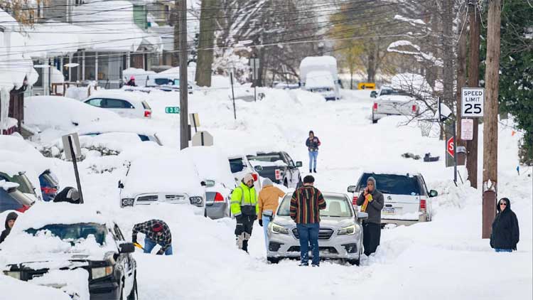
A powerful winter storm was set to lash the Great Lakes and the US Northeast on Tuesday with strong winds, heavy snowfall and bitterly cold temperatures, a day after a rapidly intensifying bomb cyclone swept across the northern United States, knocking out power to tens of thousands of customers.
The system that tore through parts of the Plains and Great Lakes on Monday ushered in sharply colder air and powerful winds, bringing a dangerous mix of snow, ice and rain that made travel hazardous. Forecasters said the storm strengthened fast enough to qualify as a bomb cyclone, a weather system that intensifies rapidly as atmospheric pressure drops.
By Tuesday morning, more than 127,000 customers nationwide were without electricity, according to Poweroutage.us, with Michigan accounting for over a third of the outages.
As the storm tracked into Canada, the National Weather Service warned that unsettled conditions would persist across the eastern US, including brief but intense snow squalls accompanied by gusty winds. Blustery conditions were expected to deepen the Arctic chill, with temperatures dropping below freezing as far south as the Florida Panhandle.
New York Governor Kathy Hochul cautioned that whiteout conditions were likely in parts of the state, including the Syracuse metropolitan area. “If you’re in an impacted area, please avoid all unnecessary travel,” she urged in a post on X.
In Michigan’s Upper Peninsula, snow accumulated rapidly on Monday, with some areas receiving up to two feet (60 cm), the National Weather Service said. Meteorologist Ryan Metzger noted that while additional snowfall was expected in the coming days, amounts would be significantly lighter.
Ferocious winds whipped up Lake Superior, where waves reaching nearly 20 feet (6 metres) forced all but one cargo vessel to seek shelter in port, according to MarineTraffic.com. On Lake Erie, strong winds pushed water toward the eastern basin near Buffalo, New York, while exposing large stretches of lakebed on the western side in Michigan — revealing even a submerged car wreck and a snowmobile.
Kevin Aldrich, a 33-year-old maintenance worker from Monroe, Michigan, said he had never seen the lake recede so dramatically. On Monday, he spotted remnants of piers dating back to the 1830s and shared photos of wooden pilings protruding from the mud. “Where those are at would typically be probably 12 feet deep,” he said. “We can usually drive our boat over them.”
Dangerous wind chills plunged to as low as minus 30°F (minus 34°C) across parts of North Dakota and Minnesota. In northeast West Virginia, nearly hurricane-force winds were recorded atop a mountain near Dolly Sods, the weather service said.
In Iowa, although blizzard conditions eased by Monday morning, strong winds continued to blow snow across highways, forcing the closure of more than 200 miles (320 km) of Interstate 35. State troopers reported dozens of crashes during the storm, including one fatal accident.
Meanwhile, on the West Coast, the National Weather Service warned that moderate to strong Santa Ana winds would affect parts of Southern California through Tuesday, raising concerns over falling trees in areas where recent rainfall had saturated the ground. Two additional storms were forecast later in the week, with New Year’s Day rain potentially soaking the Rose Parade in Pasadena for the first time in nearly 20 years.
Comments are closed.