UN General Assembly Adopts Equal Earth Map to Better Reflect True Scale of Continents

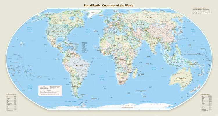
The United Nations General Assembly on Friday adopted a resolution promoting a new world map that more accurately reflects the relative sizes of the world’s continents, making Africa appear larger while reducing the visual prominence of Europe and North America.
The resolution, backed by 164 countries, called for greater use of the Equal Earth projection as an alternative to the traditional Mercator map. The United States voted against the proposal, while six countries abstained.
The resolution said the Equal Earth projection would provide “a more accurate representation” of the world’s landmasses. It urged UN member states to consider replacing the Mercator projection, created by Flemish cartographer Gerardus Mercator in 1569 primarily for maritime navigation.
Togo, which sponsored the resolution, said maps shape how people understand the world. Foreign Minister Robert Dussey argued that maps “are never neutral” and that distorted representations can reinforce inaccurate perceptions across generations.
The US, however, criticised the initiative. Ahead of the vote, US representative Yaryna Ferencevych said the debate demonstrated why the UN was “losing its credibility”, arguing that the organisation should focus on more pressing global challenges rather than historical map projections and issues such as reparations and “cognitive justice”.
Why the Mercator Map Is Controversial
The Mercator projection accurately preserves angles and shapes, making it particularly useful for navigation. However, it significantly distorts the relative size of landmasses, especially as they get farther from the equator.
As a result, Europe and North America appear much larger than they actually are, while Africa and South America appear comparatively smaller.
The Equal Earth projection, developed by a group of cartographers in 2018, was designed to preserve the relative areas of continents while maintaining shapes that more closely resemble their appearance on a globe. Africa, Latin America, South Asia and Oceania consequently appear substantially larger than on Mercator maps.
Cartographer Bojan Savric said in 2025 that Equal Earth preserves the relative surface areas of continents while showing their shapes as accurately as possible.
France, which co-sponsored the UN resolution, also announced Friday that it would move away from the Mercator projection.
French Foreign Minister Jean-Noel Barrot said the traditional map gives disproportionate visual prominence to the United States, Russia and China, while making Greenland appear almost as large as Africa.
“Changing maps obviously doesn’t change the world,” Barrot said, adding that correcting a distorted representation was “already an act of truth.”
The move comes as France seeks to strengthen ties with African countries, particularly former French colonies where relations have become increasingly strained in recent years.
Comments are closed.