Heavy Rains Lash Tamil Nadu as Twin Low-Pressure Systems Intensify; 8 Districts on Red Alert
Two well-marked low-pressure systems over the Bay of Bengal and the Arabian Sea have intensified into a depression, triggering widespread heavy rainfall across several parts of Tamil Nadu on Tuesday.
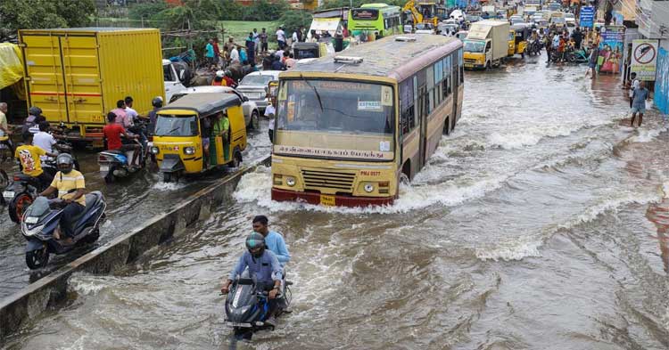
The Regional Meteorological Centre (RMC) in Chennai placed eight districts — including Ramanathapuram, Nagapattinam, Cuddalore, and Thanjavur — on red alert, indicating the likelihood of extremely heavy rainfall. Chennai and its adjoining districts have been placed under an orange alert.
Between 8:30 a.m. and 5:30 p.m. on October 21, the highest rainfall in the state was recorded at Chennai’s Nungambakkam station with 61.8 mm, followed by Pamban in Ramanathapuram (53 mm) and Madurai (41 mm).
The RMC forecasted heavy rainfall over Tamil Nadu and Puducherry until October 22, after which the intensity is expected to reduce to moderate and light rain. The India Meteorological Department (IMD) warned that the twin weather systems could bring 7 cm to 20 cm of rainfall, with isolated areas likely to receive more than 21 cm.
Chief Minister M.K. Stalin chaired a high-level meeting in Chennai on Tuesday with the disaster management department and officials from delta districts via video conference to review monsoon preparedness. He directed district monitoring officers to immediately reach regions placed under red and orange alerts and appointed a senior IAS officer for each of the 12 districts expected to face heavy rainfall.
“The chief minister instructed that relief camps be kept ready and emphasized precautionary measures in low-lying areas,” a government statement said. Equipment such as JCBs, boats, and motor pumps have been deployed for emergency response, while officials also inspected paddy storage facilities in the delta region.
Deputy Chief Minister Udhayanidhi Stalin inspected rain-affected zones in Chennai and confirmed that additional motor pumps have been stationed in low-lying neighborhoods to prevent waterlogging.
According to the RMC, an upper air cyclonic circulation over the South Bay of Bengal led to the formation of a low-pressure area on Tuesday. “It is likely to move west-northwestwards and concentrate into a depression over the southwest and adjoining west-central Bay of Bengal off the north Tamil Nadu–Puducherry–Karaikal and south Andhra Pradesh coasts by Wednesday afternoon (October 22),” the agency said.
The northeast monsoon has remained active across Tamil Nadu, with temperatures dropping notably — Chennai recorded a maximum of 28°C on Tuesday
Comments are closed.